*ORAC (Optimal Retrieval of Aerosol) CC4CL (Cloud CC4CL Community Code for Climate).
The algorithm is based on fitting a physically consistent cloud and aerosol models to satellite observations simultaneously from the visible to the mid-infrared, thereby ensuring that the resulting cloud and aerosol properties provide both a good representation of the short-wave and long-wave radiative effects of the observed pixel. The advantages of the optimal estimation method are that it enables rigorous error propagation and the inclusion of all measurements and any a priori information and associated errors in a rigorous mathematical framework. The algorithm provides a measure of the consistency between retrieval representation of cloud and aerosol and the satellite radiances. The algorithm can and has been applied to most visible/infrared satellite instruments such as ATSR, AVHRR, MODIS, SEVIRI and HIMAWARI.
The code is available open source and we welcome new developers. If you are interested in using the code please read the information on this website and contact Gareth Thomas to obtain access.
Aerosols influence the global energy budget through both direct and indirect radiative effects. The aerosol direct radiative effect results from the change in reflected sunlight off of an aerosol layer in a cloud-free environment. The sign and strength of the direct radiative effect varies depending on the absorption characteristics of the aerosol layer. For example, sulphate aerosols tend to enhance the reflection of solar radiation to space and cool the atmosphere while black carbon particles tend to absorb this energy and heat the atmosphere. Aerosols also indirectly influence the radiation budget by modifying the micro and macrophysical properties of clouds. These changes typically work in concert together to enhance cloud albedo. The cooling effect related to the aerosol indirect
effect is the most uncertain radiative forcers related to climate change (IPCC 5th assessment report). Here, ORAC is used to quantify direct and indirect aerosol radiative effects by combining aerosol and cloud CCI datasets. Relationships are examined at 1x1 degree resolution using joint histograms of aerosol and cloud properties. To improve the quality of the satellite products we have developed a 'nearest neighbor' approach to remove aerosol retrievals near cloud edges and limit 'cloud contamination' that has plagued previous studies of this kind. Furthermore, 17 years of satellite data from the Advanced Along Track Scanning Radiometer series is being used to calculate the aerosol indirect radiative forcing and improve the uncertainty of this estimate.
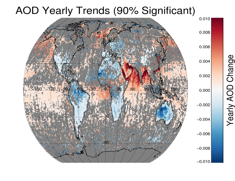
Figure (left): Plot of significant aerosol trends detected by the ATSR series of instruments from 1995-2012
The ATSR series of instruments
The Advanced Along Track Scanning Radiometer (AATSR) is one of the Announcement of Opportunity (AO) instruments on board the European Space Agency (ESA)'s Envisat satellite.
This instrument is a multi-channel imaging radiometer with the principal objective of providing data concerning global Sea Surface Temperature (SST) to the high levels of accuracy and stability required for monitoring and carrying out research into the behaviour of the Earth's climate.
ATSR can measure Earth's surface temperature to a precision of 0.3 K (0.5 °F), for climate research. Among the secondary objectives of AATSR is the observation of environmental parameters such as aerosols, clouds, fires, gas flares, water content, biomass, and vegetal health and growth. AATSR is the successor of ATSR-1 and ATSR-2, payloads of ERS-1 and ERS-2. The first instrument was launched in 1990 and the last measurement was made in March 20102. A new instrument in the series SLSTR (Sea and land Surface radiometer) is scheduled for launch in December 2015.
The ATSR series of instruments is ideal for studying cloud and aerosol properties, the dual view provides an accurate atmospheric correction, the instrument is well calibrated with on board visible and IR calibration and is vicariously calibrated with ground sites. Finally the instruments and platforms have maintained a stable orbit.
Links
Key references
Stengel, M., et al.: The Clouds Climate Change Initiative: Assessment of state-of-the-art cloud property retrieval schemes applied to AVHRR heritage measurements, Remote Sens. Environ., doi:10.1016/j.rse.2013.10.035, 2013.
Poulsen, C. A., Watts, P. D., Thomas, G. E., Sayer, A. M., Siddans, R., Grainger, R. G., Lawrence, B. N., Campmany, E., Dean, S. M., and Arnold, C.: Cloud retrievals from satellite data using optimal estimation: evaluation and application to ATSR, Atmos. Meas. Tech. Discuss., 4, 2389-2431, doi:10.5194/amtd-4-2389-2011 (Accepted June 2012)
For more information please contact: RAL Space Enquiries