This major milestone in the life of The Sea and Land Surface Temperature Radiometer (SLSTR) was reached as the sensor departed the Science and Technology Facilities Council (STFC) RAL Space Centre for Calibration, heading for integration with the Sentinel 3 satellite in Cannes, having undergone a series of thermal vacuum and calibration tests. The calibration is to assure the instrument’s highly accurate measurements of global Earth surface temperatures for climate monitoring.
The sensor, which National Centre for Earth Observation (NCEO) experts will use for a range of climate research, is particularly designed to derive Sea-Surface Temperatures (SSTs). To get maximum understanding of climate, these new data will be carefully combined with SST from previous satellite instruments to measure changes across decades.Data from SLSTR will provide continuity of the climate quality sea surface temperature (SST) data collected by the Along Track Scanning Radiometer (ATSR), which over the last 20 years has much improved spatial and temporal coverage.Simulation of the interplay of ocean and atmosphere is crucial to being able to predict future tendencies of the weather and climate, and SST that will be used by climate modellers to test their models.
Professor Chris Merchant of NCEO and University of Reading said, "We are very much looking forward to obtaining data from the first Sentinel 3 mission. Because of SLSTR's design and calibration, the sea surface temperature measurements we will derive from its images should be very trustworthy. This helps us track the behaviour of climate.”
SLSTR has been developed through a collaboration between Selex ES (Florence), Jena Optronik, and STFC-RAL Space for the ESA/EU Copernicus Sentinel 3 Satellite led by Thales Alenia Space in Cannes.
Dr Chris Mutlow, Director of RAL Space said "SLSTR is a second generation SST sensor which will carry on the climate observations started by the ATSR programme. The successful completion of the SLSTR instrument calibration has required a great deal of hard work from our team at RAL over the last few months, and represents a major milestone for ESA/EU and all the contractors around Europe who have spent years building the instrument. Like the rest of the science and operational communities we are now keen to have SLSTR in space, operational and delivering high-quality SST data to users”.
The calibration was performed in a purpose built rig designed to allow the SLSTR instrument to view the different calibration sources under carefully controlled conditions that replicates the in-flight environment. The measurements ensure that the calibration of the data generated by SLSTR can be traced to reference standards as required for accurate climate monitoring.
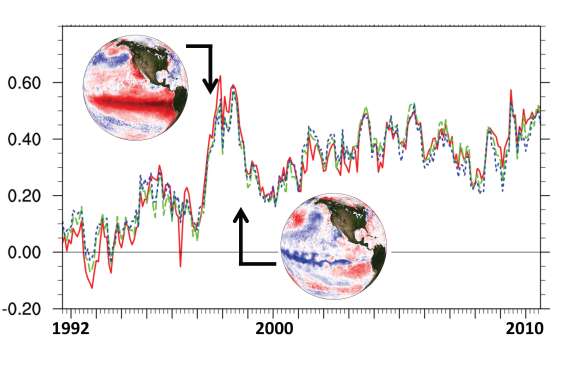
Figure 1 (below) shows Sea Surface Temperature changes based on data from the world leading UK Along Track Scanning Radiometers (ATSR). Dashed lines are estimates from in situ data sources.Solid lines are satellite data. The globes show during and after a big El Nino Southern Oscillation with red = warm; blue = cold. In an El Nino year (top), global temperatures are much higher on average than in a La Nina year (bottom) with temperature patterns which drive global weather.
These activities require major computing power, and the UK has created a facility for collecting and processing large volumes of SLSTR and other data, at Harwell.
Professor John Remedios, Director of NCEO said "The Along Track Scanning Radiometers (ATSRs) and the new Sea- and Land- Surface Temperature Radiometers (SLSTRs) show how the UK is delivering significant evidence regarding the magnitude of change in ocean temperatures. The high quality data from these instruments also serves many operational applications which add value to this core mission which involves many leading UK scientists.”
NCEO experts will be using the SLSTR instrument to provide essential new information on the land including fires and land surface temperature. It has two specifically designed detector systems which are sensitive enough to detect fires burning across as little as 100 m², which is only 1/10000th of the area covered by a single SLSTR pixel. Professor Martin Wooster of NCEO and King's College London hopes to use this important data to map the radiative heat emitted by fires burning worldwide, and relate this to emissions of carbon dioxide and other gases and aerosols. In an El Nino year, the impact of fires on Earth's land and atmosphere can be especially severe, as was the case in 1997-1998.