UK scientists are celebrating the successful launch of the newest Earth monitoring satellite in Europe’s Copernicus programme, Sentinel-3B, from the Russian Plesetsk Cosmodrome on a Rockot at 17:57 GMT on Wednesday.
STFC’s RAL Space has been involved in developing the Sea and Land Surface Temperature Radiometer (SLSTR), one of the five instruments on board Sentinel-3B. SLSTR’s job is to provide highly accurate measurements of global Earth surface temperatures, vital information for monitoring events like the El Niño phenomenon in the Pacific Ocean, even tracking wildfires.
The satellite has now taken its place in orbit to work with its twin, Sentinel 3A, to monitor the land and sea. Part of the ESA/EU Copernicus family of Earth observation missions, Sentinel 3 supports ocean forecasting systems, as well as environmental and climate monitoring. The two satellites will fly in tandem providing better estimates of the quality of data coming from both satellites and help record accurate long-term climate data records, an area in which the UK has world-class capability.
Scientists and engineers at RAL Space calibrated SLSTR for both Sentinels 3A and 3B to ensure that the instruments provide the high level of accuracy required. To ensure that data from SLSTR, can be reliably traced to reference standards required for accurate climate monitoring, RAL Space were responsible for the overall calibration strategy, including the on-board calibration sources, pre-launch test campaigns and on-orbit verification.
Dr Chris Mutlow, Director of STFC RAL Space said, “A successful launch of a satellite is always a great moment in a project, particularly when it’s a project you have worked on yourself. We’re now looking forward to the enhanced global coverage Sentinel 3B will provide, working in tandem with Sentinel 3A. This data is vital to our understanding of environmental phenomena. I’m proud of the role RAL Space scientists and engineers play as part of the European team making this as accurate as possible.”
SLSTR continues the dataset of global surface temperatures collected by the Along-Track Scanning Radiometer (ATSR) series on ERS1, ERS2 and ENVISAT. The ATSR series, originally developed by a UK consortium led by RAL Space, are considered amongst the most accurate remote sensing instruments in terms of data calibration. As such, the data from ATSR are used as a reference for other satellite instruments measuring sea surface and land surface temperature.
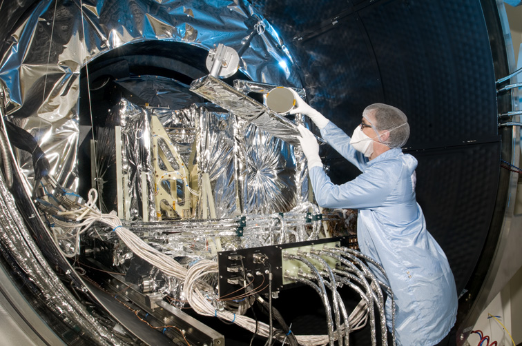
Image: An engineer prepares SLSTR for testing in a vacuum chamber.
Credit: STFC RAL Space
Dave Smith, SLSTR Calibration Scientist at STFC RAL Space said: “The launch of Sentinel-3B completes the latest chapter in the story of the Along Track Scanning Radiometer that began in the 1980's. From its beginnings as a research instrument to measure sea surface temperatures to unprecedented accuracy, we now have two operational instruments that will be providing global, daily measurements of the highest quality. The story will continue with SLSTR-C and D and beyond."
As well as calibration, RAL Space played a key role in the development of the instrument design, and the definition of the data products and processing algorithms. RAL Space lead the SLSTR Expert Support Laboratory to ensure that the data quality are of the standard required for operational and climate users. Data from Sentinel 3B will be made available to scientists through the Centre for Environmental Data Analysis archive; which already holds over 3.5 Petabytes and 2.8 million data products of Sentinel data.
Work is now in progress on the SLSTR instruments for Sentinels 3C and 3D which will replace 3A and 3B at the end of their operational lifetime. SLSTR for Sentinel 3C will be arriving at RAL Space in 2019 for calibration.
Speaking from a meeting of the international space co-ordination body, the Committee on Earth Observation Satellites, Professor John Remedios Director of the UK’s National Centre of Earth Observation (NCEO) said: “Sentinel-3B marks an important step forward in our capability to provide high quality data as fast as possible for wherever people live and move. Together with Sentinel-3A, it marks a point of markedly improved precision and regional representations in our climate records for land, ocean and particles in the atmosphere”
SLSTR has been developed through a European collaboration between Leonardo Company (Italy), Jena Optronik (Germany), and STFC RAL Space for the ESA/EU Copernicus Sentinel 3 satellite led by Thales Alenia Space in France.
Notes for editors
Sentinel 3B
The Sentinels are a fleet of satellites designed to deliver the wealth of data and imagery that are central to the European Commission’s Copernicus programme.
This unique environmental monitoring programme is making a step change in the way we view and manage our environment, understand and tackle the effects of climate change and safeguard everyday lives. It serves European citizens, both directly through its products and applications, and indirectly through social, economic and environmental benefits.
SLSTR has been developed through a European collaboration between Leonardo Company (Italy), Jena Optronik (Germany), and STFC RAL Space for the ESA/EU Copernicus Sentinel 3 satellite led by Thales Alenia Space in France.
Media contact:
Madeleine Russell
Communications Officer, RAL Space
Tel: +44 (0) 1235446288 | Mob: +44 (0) 7594083386
STFC RAL Space is an integral part of the Science and Technology Facilities Council's (STFC) Rutherford Appleton Laboratory (RAL). RAL Space carries out world-class space research and technology development with involvement in over 210 space missions to date.
The National Centre for Earth Observation (NCEO) is part of the UK’s Natural Environment Research Council (NERC) and is a distributed centre with over 100 scientists from UK institutions, led by Professor John Remedios at the University of Leicester. It provides NERC with national capability in Earth observation science and incorporates world-class capabilities in interpretive Earth observation to meet the needs of society through long-term core science and translation of knowledge and environmental data for government and business.